Milestone Target:
Waldemar Lindgren, a Swedish-American geologist and one of the founders of Economic Geology, visited DeLamar in 1900 and described the Milestone target within the BlackSheep target as a “Spring Deposit” consisting of a ledge of flinty greyish to brownish quartz carrying numerous silicified organic remains situated within the porphyritic rhyolite.
Roderick Asher, an American geologist and engineer born in Idaho, wrote a report in 1968 describing a number of prospects and mineralized areas in the BlackSheep area. Asher described a zone at Milestone composed of angular rhyolite fragments cemented by quartz with abundant pyrite. This breccia zone is approximately 20 feet (6 m) wide and can be traced on surface for roughly 150 feet (46 m). The zone is cut by vertical joints that strike N30W. A caved shaft and several historic pits are in the breccia zone and date back to the late 1800s/early 1900s.
Historic adits in the BlackSheep area were also noted by Asher on similar breccia zones extending to the north of Milestone. These breccia zones can be traced by intermittent surface exposures for about 2,000 feet (610 m). Due to alluvial cover contacts are not clear, but the zone is possibly 100 feet (30 m) wide. Several old adits penetrate the breccia and one adit, at the west end of the zone, is open and accessible. Both walls of this adit show brecciated silicified rhyolite. The breccia fragments are surrounded by a thin coating of soft, white clay, containing disseminated, tiny, black blebs and specks that Asher presupposed might be argentite. A narrow fault, which trends N50E and dips 500 W, is partially filled with a similar white clay. The clay in the fault is 6 inches to 8 inches (15 cm to 20 cm) in width.
Georgianna Target:
Asher describes the Georgianna Target as a highly siliceous brecciated rhyolite body. A large bulldozer pit exposes the mineralization in an area about 1,000 feet by 500 feet (305 m by 152 m). Loose rock fragments in the pit are crossed by veinlets and bands of white chalcedonic quartz with thin seams of argentite or other silver minerals disseminated in the bands. The quartz veinlets are 2 to 3 inches (5 to 8 cm) in width. In some specimens, discrete veinlets of what appears to be argentite are in the quartz bands. Pyrite is widespread throughout the exposure as veinlets and disseminations. No mineralization was found in place, hence the full limits of the area of mineralization are not known. Loose silicified float occurs over much of the pit. Asher presupposes that this suggests there is a large zone of disseminated mineralization.
North of the bulldozer cut is a caved, historic adit. The adit is almost 50 feet (15 m) lower in elevation than the cut. There is an historic shaft roughly midway between the pit and the adit. The dump at the adit shows basalt indicating that the rhyolite may not be much more than 50 feet (15 m) thick. No mineralization was noted in the basalt on the dump. A second caved, historic adit is approximately 2,000 feet (610 m) west of the previously described bulldozer pit. Material on the dump indicates that the adit was driven into a pyritized breccia zone, although there are no indications of such a zone on the surface. A longtime Jordan Valley resident says the Georgianna and Argentum areas were originally worked by a set of brothers in the late 1800s/early 1900s; however, the bulldozer work described by Asher was probably done by a Johns Manville exploration team in the early 1960s.
Twin Peaks Target:
Asher described eight, short historic adits at the Twin Peaks target, in addition to prospect pits within a zone of white rhyolite on the south peak at Twin Peaks. The historic prospect pits are on the west side of the peak 150 to 200 feet (46 to 61 m) below the summit. These historic pits are approximately 50 feet (15 m) apart. The rhyolite in the vicinity of the dumps is sericitized and many of the rocks have a white, chalky coating on their surface. The historic prospect pits are excavated in a volcanic dome of rhyolite. Disseminated pyrite is abundant in rock specimens from the dumps, and cellular quartz is common. The pyrite is generally associated with highly siliceous brecciated rhyolite. The line of prospects trends about N40W across the slope of the peak. At one pit a poorly exposed, narrow fracture with cellular quartz strikes N45W and dips 300W. A historic adit was driven to the north base of the south peak and finely disseminated pyrite occurs in sericitized rhyolite on the historic dump.
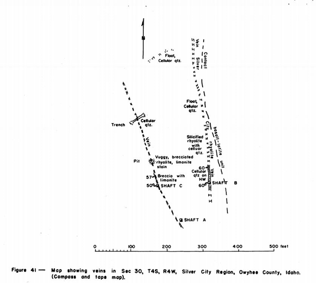
Lucky Days Target:
Asher describes two veins showing cellular quartz at the Lucky Days target. The south end of the prospect has three historic shafts which have been sunk into these veins, and there are several shallow (historic) prospect pits extending along the length of these veins. Further north there is a small mass of granitic rock that protrudes through the surrounding volcanic cover. One of the veins crops out in the granitic rock and an adit has been driven into the vein. Judging from the size of the dump, the adit is 500 to 600 feet (152 to 189 m) long.
There is Silver City rhyolite that crops out nearby and a second adit has been driven into it. The dump at shaft A (see diagram below) shows highly altered rhyolite with yellowish red limonite on the surface of the rock fragments. The rocks are sericitized. The vein at shaft A is about 6 feet (1.8 m) wide and shows white cellular quartz on the hanging wall and white siliceous rhyolite on the footwall. The vein can be traced to the North for roughly 400 feet (122 m) by the presence of float fragments and sparse outcrops of cellular quartz. The vein strikes north and dips 600W. Shaft B (see diagram below) is inclined 60W and was sunk on the most northerly of the veins.
Shaft C (see diagram below) is approximately 150 feet (46 m) west of shaft 8 on a different vein. The shaft is inclined about 500W down dip of the vein. Pits and trenches in the area expose the vein to the north 350 feet (107 m) from shaft C. The vein most likely extends to the south for 150 feet (46 m) to shaft A. On the surface, the shaft C vein is expressed by a gossan zone of red limonite. Cellular quartz and brecciated quartz are also associated with the vein. The vein is about 4 feet (1.2 m) wide, strikes northwest and dips 50W to 600W. Rare float fragments indicate that the eastern vein, or vein at shaft 8, continues to the north and is the same vein exposed in a small pod of granite nearby. A vein of white massive quartz about 50 feet (15 m) wide is in the granitic rocks. Indications are that this vein is barren.
The vein is not well expressed in the rhyolite flanking in the granitic pod, but specimens from the dump of the historic adit in the rhyolite show finely disseminated pyrite cubes in a mass of orthoclase or valencianite crystals. Exploration of these veins is evident from the old shafts and adits in the vicinity. Nothing is known of their history. The veins have a considerable strike length and warrant further exploration. There is a short, caved historic adit West of the previously described veins The historic dump at this adit shows brecciated rhyolite with much cellular quartz. The vein is not exposed on the surface. According to a longtime Jordan Valley resident, these workings were dug by a prospector named Sullivan before WW1.
The targets and/or locations described above began to be referred to as the BlackSheep area in the 1960s, presumably when the prospects were staked as mercury targets. During this period, three shallow holes (~50 to 70 feet (15 to 21 m) were drilled, presumably to test for mercury mineralization. In the late 1980s, Johns Manville, an international industrial minerals producer, mounted a gold exploration project on the Owyhee Plateau of eastern Oregon and western Idaho. Sampling of the BlackSheep prospect by Johns Manville geologists yielded anomalous gold and silver values in both the hot spring deposit cap and the underlying volcanic rocks. These geologists recognized the geology at BlackSheep as that typical of a hot springs precious metal deposit. Johns Manville, and other companies that followed, were unable to make a deal with the owner for the BlackSheep area. Coincident with this work, geologists from the Delamar Mine (which operated from the mid-1970s to the late 1990s) discovered a small low-grade gold-silver deposit on their claims to the southeast of the old mercury prospects at BlackSheep and named this deposit Milestone.